

Trip West 2019
Yes, you can email us!


Homeward Bound
Oregon
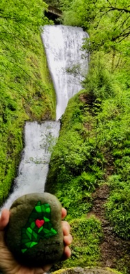
Bridal Veil Falls
Oregon
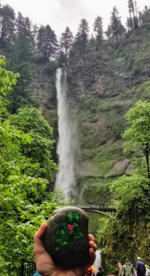
Multnomah Falls
Oregon
After what seemed to be a very quick two weeks with family, we are once again on the road...only east bound this time. Along the Columbia River Scenic Highway we stopped for a short walk to two different waterfalls. Following a meandering path with lots of switchbacks we were able to get fairly close to the base of the 120 foot tall Bridal Veil falls which flow over Larch Mountain and right under the highway. We took several pictures of flora along the way including the heavily moss covered trees.
As we neared the second fall, Multnomah Falls, traffic was noticeably heavier. Parking here is fairly limited. I can't imagine what it is like during the summer season. The 611 feet tall Multnomah Falls is by far the larger of the two Falls. Indian lore says these Falls were created to win the heart of a young princess who wanted a hidden place to bathe. From the Benson Bridge overlook you can view both the upper 542 foot drop as well as the 59 foot drop of the second tier. Both Falls are worthy of the a stop for sure.
Leaving John Day we traveled along Rt. 395…some stunning scenery on this route. Stopped for night one on the road home in John Day, Oregon at John Day Motel. Dinner at 1188 Brewing included my introduction the D's Baked Apple Wicked Cider. Probably never find it anywhere near home. Bummer, because it was really good!

Huge breakfast at Squeeze-In. Gave new meaning to short stack. While walking through town I tried out my new app called Lens Peak...it identifies peaks in your area. Found Canyon Mountain which is right outside of John Day, Oregon. Heading out of town we travel along rt 395 through the Malheur National Forest and could see the fire damage left from the 2015 Canyon Creek Complex Fire. 34,000 acres of destruction from this uncontrolled burn.


